customer success stories
Indian Forests Using DJI Mavic Drones For Forest Monitoring
Introduction
Mahabubabad Forest Department, which comes under Andhra Pradesh, which comes under the jurisdiction of Gudur, which is a southern town of Andhra Pradesh, keeps monitoring the entire forest for crucial data and also about the pre-installed latitude, longitude.
Achampet Forest Department, which comes under Telangana, also keeps monitoring their forest area for their crucial data as mentioned above.
The Challenging Task
The challenges being faced by these two telugu states for some of the monitoring purposes, the aerial survey becomes the must as the conventional method became an obsolete practice. This could probably require a drone aircraft which can make the survey through hovering around and could connect the multiple way points automatically.
The Achampet Forest Department was earnestly looking forward to a drone which could be extremely compact, foldable and equally lightweight to carry around. Further they also wanted the drone to produce 4K HDR Video, and which has an omnidirectional obstacle sensing feature for some of the aerial photography shoots in the forest area.
The Solution
We offered the solution of DJI Drones to the client, which has the capability to bring about the pre-installed latitude, longitude, and hovering around, and which could connect the waypoints during its course.
These built-in features in the device actually opens the door for absolute creativity as well as the better functionality of letting the drone aircraft to fly on its own. For easy maneuvering, the drone comes with a functionality of some of the flight modes such as: Active Track, Gesture Mode, Tap-fly, Tripod and Cinematic Modes.
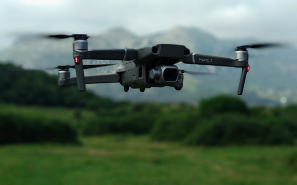
As a solution offering of the device, the divisional forest officer then opted for the DJI Mavic 2 Pro combo drone which brings with it additional intelligent flight batteries which keeps the drone functional for a prolonged period of time without having a halt when hovering across the forest area.
The drone comprised of the dual satellite system which helps the device to assist with precision flying, return to home, obstacle avoidance, way points, point of interest and much more even in the forest area where there is sufficient signal strength and a GPS is essential for the geographical tagging of aerial photographs for photogrammetry using 3D mapping software.
The Result
The solution offered by us to both these forest divisions has made their survey work much easier. Apart from that, the highly advanced professional quadcopter could eventually bring about the best video stabilization during the aerial shots.
PRODUCT VIDEOS
OTHER VIDEOS
