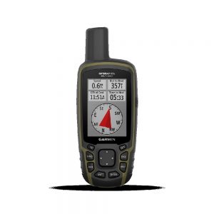
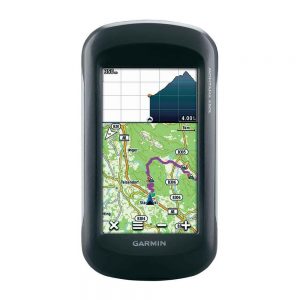
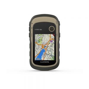
GPSMAP 66SR

0.00

Category:

Description

  • Large, 3” sunlight-readable color display for easy viewing
  • Multiple Global Navigation Satellite Systems (GNSS) support to track your travels in more challenging environments than GPS alone plus three-axis compass and barometric altimeter
  • Access to BirdsEye Satellite Imagery with direct-to-device downloads and no annual subscription• Expanded wireless connectivity supports Active Weather for up-to-date forecasts and animated weather radar and Geocaching Live for mobile syncing and updates
  • Compatible with Garmin Explore™ website and app to help you manage tracks, routes and waypoints and review statistics from the field
  • Up to 16 hours of battery life in GPS mode; 1 week in expedition mode

Specifications

General

PHYSICAL DIMENSIONS 2.5″ x 6.4″ x 1.4″ (6.2 x 16.3 x 3.5 cm)
DISPLAY SIZE 1.5″W x 2.5″H (3.8 x 6.3 cm); 3″ diag (7.6 cm)
DISPLAY RESOLUTION 240 x 400 pixels
DISPLAY TYPE transflective color TFT
WEIGHT

8.1 oz (230 g) with batteries

BATTERY TYPE Rechargeable, internal lithium-ion
BATTERY LIFE

Up to 36 hours
Up to 450 hours in expedition mode

WATER RATING IPX7
MIL-STD-810 (thermal, shock, water)
HIGH-SENSITIVITY RECEIVER  
INTERFACE high speed micro USB and NMEA 0183 compatible
MEMORY/HISTORY 16 GB (user space varies based on included mapping)

Maps & Memory

PRELOADED MAPS (basemap only)
ABILITY TO ADD MAPS  
BASEMAP  
AUTOMATIC ROUTING (TURN BY TURN ROUTING ON ROADS)  
MAP SEGMENTS 15000
BIRDSEYE (direct to device)
EXTERNAL MEMORY STORAGE (32 GB max microSD card)
WAYPOINTS/FAVORITES/LOCATIONS 10000
TRACKS 250
TRACK LOG 20000 points, 250 saved gpx tracks, 300 saved fit activities
ROUTES 250, 250 points per route; 50 points auto routing
RINEX LOGGING  

Sensors

GPS  
NavIC (IRNSS)  
GLONASS  
GALILEO  
BAROMETRIC ALTIMETER  
COMPASS (tilt-compensated 3-axis)
GPS COMPASS (WHILE MOVING)  

Daily Smart Features

CONNECT IQ (DOWNLOADABLE WATCH FACES, DATA FIELDS, WIDGETS AND APPS)  
VIRB REMOTE  
PAIRS WITH GARMIN CONNECT MOBILE  
ACTIVE WEATHER   
SMART NOTIFICATIONS ON HANDHELD  

Safety and Tracking Features

LIVETRACK  

Outdoor Recreation

POINT-TO-POINT NAVIGATION  
COMPATIBLE WITH BASECAMP  
AREA CALCULATION  
HUNT/FISH CALENDAR  
SUN AND MOON INFORMATION  
XERO LOCATIONS  
GEOCACHING-FRIENDLY (Geocache Live)
CUSTOM MAPS COMPATIBLE (500 custom map tiles)
PICTURE VIEWER  
INREACH REMOTE WIDGET  
LED BEACON FLASHLIGHT  

Outdoor Applications

COMPATIBLE WITH GARMIN EXPLORE APP  
GARMIN EXPLORE WEBSITE COMPATIBLE  

Connections

WIRELESS CONNECTIVITY

yes (Wi-Fi®, BLUETOOTH®, ANT+®)

Datasheet

Compatible with Garmin Explore™ website and app to help you manage tracks, routes and waypoints and review statistics from the field please download Datasheet.

Download Data Sheet

Accessories

Garmin GPSMAP 66SR Accessories

  Description
Usb Cable
Carabiner Clip
  User Manual