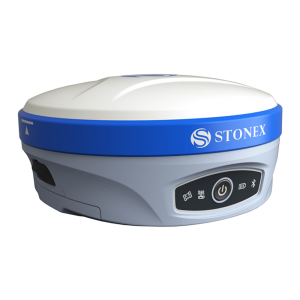
S850+ GNSS Receiver

0.00

Compact GNSS Receiver

Equipped with an advanced 1408-channel GNSS board and capable of supporting various satellite constellations, including GPS, GLONASS, BEIDOU, GALILEO and QZSS. The Stonex S850+ GNSS receiver is the ideal solution for any surveying work in the field.

The receiver’s advanced design gives the S850+ excellent signal tracking and interference resistance capabilities. The advantages of portability and speed of operation make the S850+ GNSS receiver particularly suitable for field work in areas with complex terrain.

Stonex S850+ is equipped with all the necessary connections, has built-in Bluetooth and internal Wi-Fi capabilities; has a built-in UHF radio and 4G GSM modem compatible worldwide. Stonex S850+ also integrates the IMU system that enables inclined measurement (TILT) up to 60° : quick initialization, fast and accurate surveying.

Category:

Description

MULTI CONSTELLATION

Stonex S850+ with its 1408 channels, provides an excellent on-board real-time navigation solution with high accuracy. All GNSS signals (GPS, GLONASS, BEIDOU, GALILEO and QZSS) are included, no additional cost.

IMU TECHNOLOGY (optional)

On S850+ is available the IMU technology. Fast initialization, up to 60° inclination.

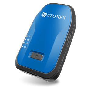
HIGH BATTERY CAPACITY AND USB TYPE-C

Stonex S850+ is delivered with a large capacity lithium battery and Type-C connector to recharge it easily.

RADIO (optional)

An activation code can enable the integrated UHF on S850+, whose range can be up to 10km under optimal conditions.

RUGGED RTK

With IP67 certification Stonex S850+ will ensure operations in various kinds of extremely tough environments.

Specifications

RECEIVER
Satellite Signals Tracked GPS: L1 C/A, L1C, L2P, L2C, L5
GLONASS: Ll, L2, L31
BEIDOU: B1l, B2l, B3l, B1C, B2a, B2b
GALILEO: E1, E5a, E5b, E6
QZSS: L1, L2, L5
IRNSS: L51
SBAS
PPP B2b PPP1 HAS1
Channels 1408
Position Rate up to 20 HZ
Signal Reacquisition < 1 sec
RTK Initialization Typically < 10 sec
Hot Star Typically < 15 sec
Initialization Reliability > 99.9%
Internal Memory 8GB
OS Linux
Tilt Sensor IMU and E-bubble (optional)2

POSITIONING3
HIGH PRECISION STATIC SURVEYING
Horizontal 2.5 mm + 0.5 ppm RMS
Vertical 5.0 mm + 0.5 ppm RMS
CODE DIFFERENTIAL POSITIONING
Accuracy < 0.40 m RMS
SBAS POSITIONING5
Accuracy < 0.60 m RMS
REAL TIME KINEMATIC (< 30 Km) - NETWORK RTK5
Fixed RTK Horizontal 8 mm + 1 ppm RMS
Fixed RTK Vertical 15 mm + 1 ppm RMS

INTEGRATED GNSS ANTENNA
High accuracy multi-constellation micro-strip antenna, zero phase center, with internal multipath suppressive board

INTERNAL RADIO (optional)2
Type Tx – Rx
Frequency Range 410 – 470 MHZ
Channel Spacing 12.5 KHZ / 25 KHZ
Range 3-4 Km in urban environment Up to 10 Km with optimal conditions6

INTERNAL MODEM
Band LTE FDD:
Bl/B2/B3/B4/B5/B7/B8/B12/
B13/B18/B19/B20/B25/B26/B28
LTE TDD” B38/B39/B40/B41
UMTS: Bl/B2/B4/B5/B6/B8/B19
GSM: B2/B3/B5/B8
Nano SIM card

COMMUNICATION
I/O Connectors 5-pin Lemo connects the external power supply and external radio Type-C, for receiver power supply and data transfer
Bluetooth V2.1+EDR V5.0
Wi-Fi 802.11 b/g
Web UI To upgrade the software. manage the status and settings, data download, etc. via smartphone, tablet or other electronic device with Wi-Fi capability
Reference Outputs RTCM2.3, RTCM3.O, RTCM3.2 MSM, CMR, CMR+, DGPS
Navigation Outputs NMEA 0183

POWER SUPPLY
Battery Internal rechargeable 7.2 V – 6900 mAh
Voltage > 9 to 28 V DC external power input with
over-voltage protection (5-pin Lemo)
Working Time > Up to 10 hours
Charge Time Typically 4 hours

PHYSICAL SPECIFICATION
Dimensions 140 mm x 140 mm x 71 mm
Weight 1.1 Kg (with battery)
Operating Temperature -300C to 650C (-220F to 1490)F
Storage Temperature -400C to 800C (-400F to 1760)F
Waterproof / Dustproof IP67
Shock Resistance Designed to endure to a 2 m pole drop on hardwood floor with no damage
Vibration Vibration Resistant

Datasheet

Geode works with a wide range of Windows®, Windows Mobile, and Android® devices to fit your needs exactly and is especially useful for bring-your-own-device workplaces. Take the Geode with you mounted on a pole, in a pack, or held in your hand to collect real-time sub-meter GNSS data in harsh environments, using almost any handheld device. please download Datasheet.

Download Data Sheet

Accessories