S580 GNSS Receiver

0.00

GNSS Receiver for GIS & RTK Applications

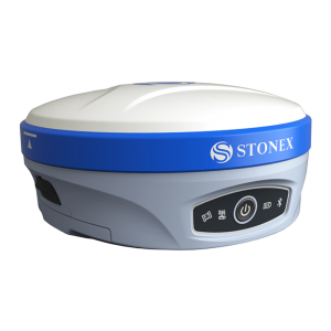
S580 is a compact and lightweight GNSS receiver, with outstanding performance and centimeter accuracy. S580 tracks dual frequency signals and works with all satellite systems (GPS, GLONASS, BeiDou, Galileo and QZSS).

Compared to traditional GIS products, the S580 is a high-precision, intelligent data acquisition receiver, that can be worn or attached to the pole, offering greater freedom of movement and flexibility. The S580 can communicate with an external device such as a tablet, smartphone or PC via Bluetooth and Wi-Fi.

Using the internal web interface, or through the Cube-connector APP, the receiver can be configured and prepared to receive RTK differential corrections and ready to be connected to any survey or GIS software. The rubber protection cover, increase device protection, non-slip and no damage, the whole device protection class reaches IP67, and resists 1.2m drops on hard surfaces.

The S580 was designed as an RTK rover receiver to receive differential corrections from the Network. However, thanks to the external Stonex SR02 radio, the receiver can also receive RTK corrections, from a base that transmits them via UHF radio modem, in the 410-470 MHz frequencies.

The SR02 external radio receives corrections from the base station and transmits them to the S580 via Bluetooth. This feature allows the S580 receiver to receive (and transmit) RTK corrections and with this capability, the receiver can be used as base and/or as rover. This configuration is an excellent and complete low-cost solution.

Category:

Description

ANDROID SYSTEM

Android system on board

FULL CONSTELLATION

GPS, Glonass, BeiDou, Galileo, QZSS

HIGH PRECISION

High precision positioning, centimetric accuracy

WEB UI

Web interface for controlling and managing settings

DATA TRANSMISSION

Wi-fi, Bluetooth and external radio

RTK AND POST-PROCESSING

S580 can work in real time with RTK corrections and simultaneously record the raw data for post-processing.

Specifications

RECEIVER
Satellite signals tracked GPS: LIC/A L2C
GLONASS: LIOF L20F
BEIDOU: Bl, B2
GALILEO: El E5b
QZSS: LIC/A. L2C
SBAS: Ll
Channels 184
Position Rate up to 10 HZ
Signal Reacquisition < 2 sec
RTK Initialization Typically > 10 sec
Hot Star Typically < 15 sec
Initialization Reliability > 99.9%

POSITIONING1
STATIC POST PROCESSING
Horizontal <2 cm + 1 ppm RMS
Vertical < 3 cm + 1 ppm RMS
CODE DIFFERENTIAL POSITIONING
Horizontal < 0.5 m RMS
Vertical < 1.0m RMS
REAL TIME KINEMATIC
Fixed RTK Horizontal < 2 cm + 1 ppm RMS
Fixed RTK Vertical < 3 cm + 1 ppm RMS

INTEGRATED GNSS ANTENNA
Full Constellation GNSS Antenna

HARDWARE
Processor SC20
RAM 512 MB
Flash Memory 8 GB
Operating System Android

EXTERNAL RADIO (optional)
Model SR02
Type TX – RX – Transceiver (2 watt)
Frequency Range 410 – 470 MHz
Channel Spacing 12.5 KHz / 25 KHz
Maximum Range 3-4 Km in urban environment
Up to 10 Km with optimal conditions

COMMUNICATION
I/O Connectors TYPE-C connector support USB 2.0
Bluetooth 2.1+EDR / 3.0 / 4.1 LE
Wi-Fi 802.11 b/g/n
Real time protocols RTCM 3.x

POWER SUPPLY
Battery Rechargeable
3.8 v – 6120 mAh
Working Time > 10 hours
Charge Time Typically 4 hours

PHYSICAL SPECIFICATION
Dimensions 136 mm x 78 mm x 31 mm
Weight 313g
Operating Temperature -400C to 650C (-400F to 1490)F
Storage Temperature -400C to 800C (-400F to 1760)F
Waterproof / Dustproof IP67
Shock Resistance Designed to endure a 12 m drop on
concrete floor with damage

STANDARD ACCESSORIES
Power Adapter, USB Cable, Belt Case, Pole Mount

OPTIONAL ACCESSORIES
Carbon Fiber Pole, Telescopic Pole, Soft Case

Datasheet

Geode works with a wide range of Windows®, Windows Mobile, and Android® devices to fit your needs exactly and is especially useful for bring-your-own-device workplaces. Take the Geode with you mounted on a pole, in a pack, or held in your hand to collect real-time sub-meter GNSS data in harsh environments, using almost any handheld device. please download Datasheet.

Download Data Sheet

Accessories